Wednesday, April 1, 2020

Disasters

Introduction

  • Disaster is an undesirable catastrophe resulting from the forces that are largely beyond human control, strikes quickly with little or no warning, and causes or threatens serious disruption of life and property. For example, earthquake, tsunami, cyclone, flood, etc.
Nepal Earthquake
  • Disasters are normally caused by nature (beyond human control); however, there are many human-induced disasters. For example, Bhopal Gas tragedy, Chernobyl nuclear disaster, wars, release of CFCs (Chlorofluorocarbons), releasing greenhouse gases, etc.
  • Besides, some disasters are natural in occurence, but those are indirectly caused by human activities. For example, landslides in hilly regions, droughts, and floods due to deforestation and other environmental damage.
  • On the other hand, Natural Hazards are the elements of circumstances in the Natural environment that have the potential to harm people or property or both.
  • The disasters are global in nature; hence, to combat with it, the United Nations made a systematic strategy at the World Conference on Disaster Management held in May 1994 at Yokohama, Japan.
  • The Yokohama conference however, is popular as the “Yokohama Strategy and Plan of Action for a Safer World.”

Categories of Natural Disaster

  • Natural Disasters are broadly categorized as −
    • Atmospheric Disasters
    • Terrestrial Disasters
    • Aquatic Disasters
    • Biological Disasters
  • Atmospheric disasters include blizzard, thunderstorm, lightning, tropical cyclone, tornado, drought, hailstorm, frost, heat wave, cold waves, etc.
  • Terrestrial disasters include earthquake, volcanic eruption, landslide, avalanches, subsidence, etc.
  • Aquatic disasters include flood, tidal waves, storm surge, tsunami, etc.
  • Biological disasters include fungal, bacterial, and viral diseases (e.g. bird flu, dengue, etc.).

Disasters’ Zone

Indian Disaster Map
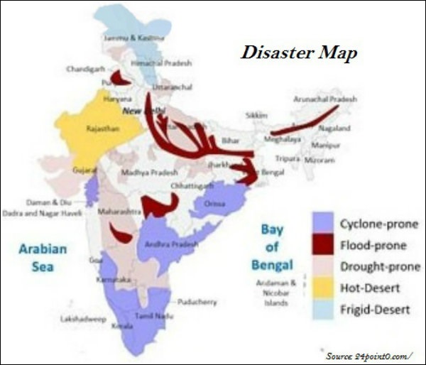
  • Very High Damage Earthquake Risk Zone in India include the north-eastern regions, areas to the north of Darbhanga and Araria along the Indo-Nepal border in Bihar, Uttarakhand, Western Himachal Pradesh (around Dharamshala) and Kashmir Valley in the Himalayan region, and the Kachchh (Gujarat).
  • High Damage Earthquake Risk Zone in India are parts of Jammu and Kashmir, Himachal Pradesh, Northern parts of Punjab, Eastern parts of Haryana, Delhi, Western Uttar Pradesh, and Northern Bihar.
  • Earthquakes and volcanic eruptions normally cause the sea-floor to move abruptly resulting in sudden displacement of ocean water in the form of high vertical waves, which are known as tsunamis (shown in the image given below).
Tsunami
  • Tsunamis can be observed frequently along the Pacific ring of fire, particularly along the coast of Alaska, Japan, Philippines, and other islands of Southeast Asia, Indonesia, Malaysia, Myanmar, Sri Lanka, and India etc.
  • Tropical cyclones are intense low-pressure areas, confined between $30^{\circ}N$ and $30^{\circ}S$ latitudes.
Cyclone Eye
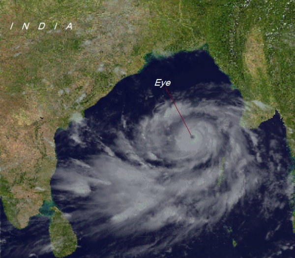
  • The center of the cyclone is mostly a warm and low-pressure, cloudless core known as ‘eye of the storm’ (as shown in the image below) −
  • The ideal location of the tropical cyclone in India is Bay of Bengal.
  • Cyclones in the Bay of Bengal normally develop in the months of October and November.
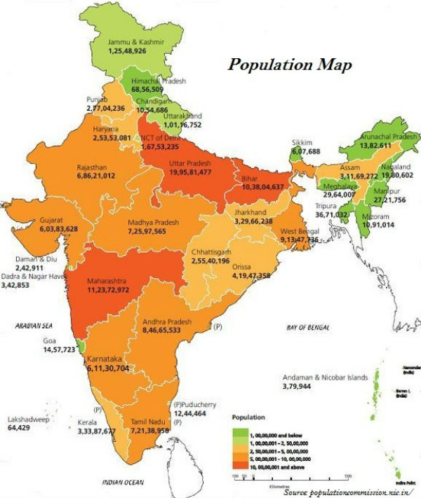
  • Rashtriya Barh Ayog (National Flood Commission) identified 40 million hectares of land as flood-prone in India.
  • Assam, West Bengal, and Bihar are the high flood-prone states of India.
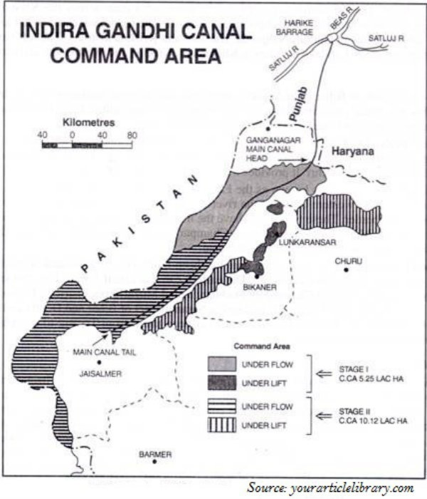
  • About 30 per cent of India’s total area comes under drought prone area, which affects about 50 million people.
  • The western part of Rajasthan is categorized as Extreme Drought Affected Areas.
  • Parts of eastern Rajasthan; many parts of Madhya Pradesh; eastern parts of Maharashtra; interior parts of Andhra Pradesh and Karnataka Plateau; northern parts of interior Tamil Nadu; southern parts of Jharkhand; and interior parts of Odisha are categorized as Severe Drought Prone Area.
  • Young mountainous areas of North and north-eastern India (the Himalayan regions), Andaman and Nicobar; high rainfall regions with steep slopes in the Western Ghats and Nilgiris; along with areas of frequent earthquakes, etc. are categorized as Very High Landslide Vulnerability Zone.

Disaster Management

  • The Disaster Management Bill, 2005, defines disaster as “a catastrophe, mishap, calamity or grave occurrence affecting any area, arising from natural or man-made causes, or by accident or negligence which results in substantial loss of life or human suffering or damage to, and destruction of, environment, and is of such nature or magnitude as to be beyond the coping capacity of the community of the affected area.”
  • A situation when there is a prolonged period of inadequate rainfall is known as Meteorological Drought.
  • When soil moisture that is necessary to support the crops, is low or insufficient to support crop cultivation, it is known as Agricultural Drought.
  • When the productivity of a natural ecosystem fails because of the shortage of water and as a consequence of ecological distress, damages occur in the ecosystem, it is known as Ecological Drought.

Regional Development

Introduction

  • India has centralized planning and the task of planning in India has been entrusted to the Planning Commission of India.
  • Planning Commission of India is a statutory body headed by the Prime Minister and has a Deputy Chairman and other members.
  • However, the Planning Commission of India is recently is now “National Institution for Transforming India” or simply NITI Aayog.
  • The planning in the country is largely carried out through the array of Five Year Plans.
  • At present, the Twelfth Five Year Plan is running, which was initiated in 2012 with a focus on ‘Faster, More Inclusive and Sustainable Growth’.

Approaches of Planning

  • Normally, there are two approaches of planning. They are −
    • Sectoral planning
    • Regional planning.

Sectoral Planning

  • Sectoral planning means formulation and implementation of the sets of schemes or programs aimed at development of various sectors of the economy such as agriculture, irrigation, manufacturing, power, construction, transport, communication, social infrastructure, and services.

Regional Planning

  • Since all the regions of India have not developed on the same lines, therefore, to reduce the regional imbalances, regional planning was introduced.

Target Area Planning

  • In order to reduce the regional and social disparities, the Planning Commission introduced the ‘target area’ and ‘target group’ approaches to planning.
  • Some of the examples of target area planning directed towards the development of target areas are −
    • Command Area Development Program;
    • Drought Prone Area Development Program;
    • Desert Development Program; and
    • Hill Area Development Program.
  • The examples of target area planning are − the Small Farmers Development Agency (SFDA) and Marginal Farmers Development Agency (MFDA).
  • Hill Area Development Programs were initiated during the Fifth Five Year Plan. The plan covers 15 districts comprising all the hilly districts of Uttarakhand, Mikir Hill and North Cachar hills of Assam, Darjeeling district of West Bengal and Nilgiri district of Tamil Nadu.
  • Major aims of Hill Area Development Program were harnessing the indigenous resources of the hilly areas through the development of horticulture, plantation agriculture, animal husbandry, poultry, forestry, and small-scale and village industry.
  • Drought Prone Area Program was initiated during the Fourth Five-Year Plan with the objectives of providing employment to the people in droughtprone areas and creating productive assets.
  • The drought prone area in India largely covers semi-arid and arid tract of Rajasthan; Gujarat; Western Madhya Pradesh; Marathwada region of Maharashtra; Rayalseema and Telangana plateaus of Andhra Pradesh & Telangana; Karnataka plateau; and highlands and interior parts of Tamil Nadu.

Planning Facts

  • In 1967, the Planning Commission of India identified 67 districts (entire or partly) of the country prone to drought.
  • In 1972, the Irrigation Commission introduced the criterion of 30% irrigated area and demarcated the drought prone areas.
  • In 1970s, the phrases such as redistribution with growth and growth and equity were incorporated in the definition of development.
  • Over period of time, the meaning of ‘Development’ did not remain restricted to ‘economic growth’ rather it also includes the issues such as improving the wellbeing and living standard of the people; availing the health facilities; education; equality of opportunity; and ensuring political and civil rights.
  • The concept of sustainable development emerged in the wake of general rise in the awareness of environmental issues in the late 1960s in the Western World.
  • The publication of ‘The Population Bomb’ by Ehrlich in 1968 and ‘The Limits to Growth’ by Meadows at al in 1972 further raised the environmental concerns.
  • The United Nations established a World Commission on Environment and Development (WCED) headed by the Norwegian Prime Minister Gro Harlem Brundtland. This is the reason that its report submitted in 1987 with the name ‘Our Common Future,’ is also known as Brundtland Report.
  • In this report, sustainable development is defined as − “development that meets the needs of the present without compromising the ability of future generations to meet their own needs.”
  • Likewise, Sustainable development takes care of ecological, social, and economic aspects of the development during the present times and pleads for conservation of resources to enable the future generations to use these resources.
Indira Gandhi Canal
  • Indira Gandhi Canal, which previously was popular as the Rajasthan Canal, is one of the largest canal systems in India.
  • The idea of Indira Gandhi Canal was proposed by Kanwar Sain in 1948; however, the canal project was launched on 31 March, 1958.
  • The canal originates at Harike barrage in Punjab and runs parallel to Pakistan border and covers an average distance of 40 km in Thar Desert of Rajasthan.

Migration

Introduction

  • During colonial period (i.e. British period) millions of the indentured laborers were sent to Mauritius, Caribbean islands (Trinidad & Tobago and Guyana), Fiji, and South Africa by British Government largely from the states of Uttar Pradesh and Bihar.
Migration
  • All such migrations were covered under time-bound contracts known as Girmit Act (Indian Emigration Act).
  • The recent wave of migrants consists of professionals including software engineers, doctors, engineers, management consultants, financial experts, and media persons to countries like USA, Canada, UK, Australia, New Zealand, Germany, etc.

Migration Facts

  • The first major modification was done in 1961 Census, as two additional components i.e. place of birth (village or town) and duration of residence (if born elsewhere) were added.
  • Further, in 1971, another component added i.e. on place of last residence and duration of stay at the place of enumeration.
  • In 1981, Information on reasons for migration were incorporated.
  • According to 2001 census, out of total 1,029 million population, 307 million (30 per cent) were reported as migrants in terms of place of birth.
  • Under the intra-state migration, numbers of female migrants are more than male (marriage related migration).
  • As per the census 2001, India has recorded that more than 5 million persons have migrated to India from other countries; largely, from the neighboring countries including Bangladesh, Nepal, and Pakistan.
  • As per the census 2001, there are about 20 million people of Indian Diaspora, spread across the 110 countries of the world.
  • In terms of in-migration, Maharashtra occupied the first place (2.3 million net in-migrants), followed by Delhi, Gujarat, and Haryana.
  • On the other hand, in terms of out-migration, Uttar Pradesh (-2.6 million) and Bihar (-1.7 million) were the top states.
  • In terms of the urban agglomeration (UA), Greater Mumbai had received the maximum number of in-migrants.

Causes of Migration

  • Causes of migration are categorized as ‘push factor’ and ‘pull factor’.
  • Push factors force people to migrate; for example, unemployment, lack of infrastructure (such as hospital, education institutions, etc.), natural disasters (such as flood, drought, earthquake, cyclone, etc.), local conflicts, war, etc.
  • Pull factors attract people from different places; for example, better opportunities for education and employment; better health facilities; and various sources of entertainment, etc.
International Migration
  • Normally, the reason behind female migration throughout India is largely marriage related; however, Meghalaya has a reverse scenario.
  • Remittances from the international migrants are one of the major sources of foreign exchange.
  • For thousands of the poor villages of states like Bihar, Uttar Pradesh, Odisha, Andhra Pradesh, Himachal Pradesh, etc. remittance acts as life blood for their subsistence.

Impacts of Migration

  • Development of slums in industrially developed states, such as Maharashtra, Gujarat, Karnataka, Tamil Nadu, and metropolitan areas, such as Delhi, Mumbai, Kolkata, etc. is a negative consequence of unregulated migration within the country.
  • One of the major negative impacts of migration is imbalances in age and sex composition at both the places − sending region (out-migration) and receiving region (in-migration).
  • Migration intermixes people of diverse cultural backgrounds
  • Because of unbalanced migration, the receiving regions (especially urban areas) are facing many environmental problems, such as pollution, depletion of ground water, solid waste management problems, etc.

Settlement

Introduction

  • A cluster of dwellings of any type and size where human beings live is known as human settlement.
Rural settlement
  • On the basis of size and type, patterns of human settlement are studied; hence, a settlement could be very small (e.g. hamlet) and could be very large (e.g. metropolitan city).
  • The sparsely populated settlement whose main occupation is agricultural and other primary sector activities, is known as village.
  • Large and densely populated settlement whose main occupational specialization is in tertiary activities is known as urban settlement.

Patterns of Settlement

The pattern of human settlement is practically influenced by −
  • Physical features (e.g. relief feature, climate, and availability of water);
  • Cultural and ethnic factors (e.g. social structure, caste, and religion);
  • Security factors (e.g. defence against thefts, robberies, etc.).

Categories of Settlement

  • Based on above discussed factors, human settlement is categorized as −
    • Clustered,
    • Agglomerated or nucleated,
    • Semi-clustered or fragmented,
    • Hamleted, and
    • Dispersed or isolated.
  • The settlement in which the houses are closely built up and compact is known as clustered settlement. The shape of clustered settlement normally varies from rectangular, radial, to linear.
  • Clustered settlement in India normally found in fertile alluvial plains and in the northeastern states.
  • The settlement, clustering in a restricted area of dispersed settlement normally looks like semi-clustered. Examples of such settlement can be seen in Gujarat plain and some parts of Rajasthan.
  • Some settlement is fragmented into several units and physically separated from each other is known as hamleted settlement. Examples of hamleted settlement can be seen in the middle and lower Ganga plain, Chhattisgarh and lower valleys of the Himalayas.
  • The isolated settlement is known as dispersed settlement. Examples of such settlement can be seen in parts of Meghalaya, Uttaranchal, Himachal Pradesh and Kerala have this type of settlement.

Types of Urban Settlement

  • Like rural settlement, urban settlements have also been developed during the ancient period itself.
  • Based on Time, Location, and Function, Urban Settlement is categorized as −
    • Ancient City
    • Medieval City
    • Modern City
    • Administrative City/Town
    • Industrial City
    • Transport City
    • Commercial City
    • Mining City
    • Cantonment City
    • Educational City
    • Religious City
    • Tourists’ City
  • Varanasi, Prayag (Allahabad), Pataliputra (Patna), Madurai, etc. are the examples of ancient city.
  • Delhi, Hyderabad, Jaipur, Lucknow, Agra, Nagpur, etc. are the examples of medieval city.
  • Surat, Daman, Panaji, Pondicherry, etc. are the examples of modern city.
  • Chandigarh, Bhubaneswar, Gandhinagar, Dispur, etc. are the cities developed after the independence of India.
  • Ghaziabad, Rohtak, Gurgaon, etc. are the satellite towns that have been developed around Delhi.
  • The town or cities performing administrative works are categorized as administrative towns/cities. For example, the national capital (New Delhi) and the capital of all states and Union Territories are the administrative towns/cities.
  • The towns/cities that developed because of the industrial development are known as industrial towns/cities. For example, Mumbai, Salem, Coimbatore, Modinagar, Jamshedpur, Hugli, Bhilai, etc.
  • The towns/cities primarily engaged in export and import activities are known as transport towns/cities. For example, Kandla, Kochchi, Kozhikode, Vishakhapatnam, etc.
  • The towns/cities primarily engaged in trade and business are known as commercial towns. For example, Kolkata, Saharanpur, Satna, etc.
  • The towns that developed because of the mining activities are known as mining towns. For example, Raniganj, Jharia, Digboi, Ankaleshwar, Singrauli, etc.
  • The towns that developed as garrison towns are known as Garrison Cantonment towns. For example, Ambala, Jalandhar, Mhow, Babina, Udhampur, etc.
  • The towns that developed because of the development of educational institutions are known as educational towns. For example, Roorkee, Varanasi, Aligarh, Pilani, Allahabad etc.
  • Some towns mark their development with the existence of religious shrines. Such towns are known as religious towns. For example, Varanasi, Mathura, Amritsar, Madurai, Puri, Ajmer, Pushkar, Tirupati, Kurukshetra, Haridwar, Ujjain, etc.
  • The towns that developed because of the influx of tourists are known as tourists’ towns. For example, Nainital, Mussoorie, Shimla, Pachmarhi, Jodhpur, Jaisalmer, Udagamandalam (Ooty), Mount Abu, etc.

Modern Indian Cities

  • Based on the population size, the census of India classifies urban centers into six classes (see the table given below).
S.No.Classes & Population
1
Class I
100,000 and above
2
Class II
50,000 to 99,999
3
Class III
20,000 to 49,999
4
Class IV
10,000 to 19,999
5
Class V
5,000 to 9,999
6
Class VI
less than 5000
  • The cities with population beyond five million are known as mega cities.
  • Urban agglomeration forms in a situation when a town and its adjoining urban areas outgrowth, or two or more contiguous towns with or without their outgrowth, or a city and one or more adjoining towns with their outgrowth together forming a contiguous spread.
  • More than 60 per cent of urban population in India lives in Class I towns.
  • Out of total 423 cities, 35 cities/urban agglomerations are metropolitan cities and six of them are mega cities.

The People

Introduction

Indian Population Map
  • Throughout the country, India has a highly uneven pattern of the population distribution.
  • Uttar Pradesh has the highest population followed by Maharashtra, Bihar, and West Bengal.
  • Terrain, climate, and availability of water largely determine the pattern of the population distribution. However, socio-economic and historical factors also affect the pattern of population distribution.
  • As per the 2011 census, urban population of India was 31.16% (the details of major urban center is illustrated in the following map).
Urban Population
  • As per census 2011, the annual population growth rate is 1.64 percent.
Top Ten Cities

Population Density

  • The density of population is expressed as the number of persons per unit area.
Indian Population Density
  • The density of population in India as per 2011 census is 382 persons per square km.
  • Bihar with 1102 people per square km is the most densely populated state of India followed by West Bengal (1029) and Uttar Pradesh (828).
  • Physiological density refers to the total population divided by the net cultivated area.
  • Agricultural density refers to the total agricultural population divided by the net cultivable area.
  • Agricultural population includes cultivators and agricultural laborers and their family members.

Phases of Population Growth

India’s population can be analyzed in four phases −
  • Phase I, the period between 1901 and 1921 − This period is known as stagnancy period, as the birth rate and death rate both were high and the population growth rate was very slow.
  • Phase II, the period between 1921 and 1951 − It was the period of steady population growth.
  • Phase III, the period between 1951 and 1981 − It was the period of population explosion in India.
  • Phase IV, from 1981 to till date − Population growth rate though still high, but reflecting a decreasing trend.

Population Composition

  • As per census 2011, 68.8 per cent of the total population lives in village and 31.2 per cent of the population lives in urban areas.
  • Considering the economic status, population can be divided into categories such as main workers, marginal workers, and non-workers.
  • As per the census 2011, main workers and marginal workers collectively constitute only about 39.8 percent of total population; rest are non-workers.
  • About 54.6 per cent of the total working population are cultivators and agricultural laborers
  • About 41.6 % are other workers, such as non-household industries, trade, commerce, construction, repair, and other services.
  • The number of female workers is relatively high in the primary sector.
  • The proportion of workers in agricultural sector in India has shown a declining trend over the last few decades; in 2001, it was 58.2%, whereas, in 2011, it was 54.6%.

Literacy

  • As per the 2011 census, literacy rate of India was 74.04% (the details of literacy rate is illustrated in the following map − state-wise).
India Literacy

Sex Ratio

  • As per the 2011 census, sex ratio of India was 940 females per 1000 males (the details of sex ratio is illustrated in the following map − state-wise).
Indian Sex Ratio

Languages

  • In India, there are 22 scheduled languages and hundreds of non-scheduled languages.
  • Among the scheduled languages, Hindi is the highest spoken language and Kashmiri and Sanskrit have the least number of speakers.
FamilySub-FamilySpoken Region
Austric (Nishada)
1.38%
Austro-Asiatic
Austro-Nesian
Meghalaya, Nicobar Islands, West Bengal, Bihar, Odisha, Assam, Madhya Pradesh, Maharashtra
Dravidian (Dravida)
20%
Tamil Nadu, Karnataka, Kerala, Andhra Pradesh, M.P., Odisha, Maharashtra, Bihar
Sino-Tibetan
(Kirata), 0.85%
Tibeto–Myanmari
Siamese-Chinese
Jammu & Kashmir, Himachal Pradesh, Sikkim, Arunachal Pradesh, Assam, Nagaland, Manipur, Mizoram, Tripura, Meghalaya
Indo–European (Aryan)
73%
Indo-AryanJammu & Kashmir, Jammu & Kashmir, Punjab, Himachal Pradesh, U.P., Rajasthan, Haryana, M.P., Bihar, Odisha, West Bengal, Assam, Gujarat, Maharashtra, Goa.

Religions

  • Religion is one of the most integral parts of the population composition of India.
  • More than 80 percent of the population comprises of Hindus followed by Muslims, Christians, Sikhs, Buddhists, and Jains.