Wednesday, April 1, 2020

Foreign Trade

Introduction

  • In 1950-51, India’s external trade was worth Rs.1, 214 crores, which rose to Rs. 22, 09,270 crores in 2009-10.
Indian Foreign Trade
  • Though an increase has been registered in floricultural products, fresh fruits, marine products, and sugar, there has been a great decline in the exports of traditional items such as coffee, spices, tea, pulses, etc.
  • Engineering goods, gems, and jewelry contribute to a larger extent to India’s foreign trade.
  • With the Green Revolution in 1970s, the import of food grains declined, but it was replaced by fertilizers and petroleum.
  • Other major items of India’s import include pearls and semi-precious stones, gold and silver, metalliferous ores and metal scrap, non-ferrous metals, electronic goods, etc.

Trading Partners

  • The share of Asia and ASEAN in total trade (with India) is increased from 33.3 per cent in 2000-01 to 57.3 per cent in the first half of 2011-12, while that of Europe and America fell from 42.5 per cent to 30.8 per cent respectively.
  • The USA, which was in first position in 2003-04 has been relegated to third position in 2010-11.
  • The UAE is becoming India’s largest trading partner, followed by China (2010-11).
  • Sea route is the major trading route for the Indian trade.

Sea-Ports

  • At present, India has 12 major ports and 185 minor or intermediate ports.
  • The 12 major ports handled about 71 per cent of the country’s oceanic traffic in the year 2008-09.
  • The capacity of Indian ports increased from 20 million tons of cargo handling in 1951 to more than 586 million tons in 2008-09.
  • Kandla Port located in the Gulf of Kachchh, on the west coast of Gujarat has been developed as a major port.
  • Kandla port is specially designed to receive large quantities of petroleum and petroleum products and fertilizer.
  • Mumbai has a natural harbor and it is the biggest seaport of the country.
Indian Sea Ports
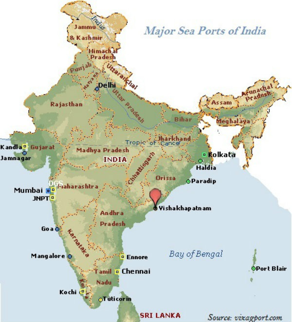
  • Mumbai port is situated closer to the general routes from the countries of Middle East, Mediterranean countries, North Africa, Europe, and North America where the major share of country’s overseas trade is carried out.
  • Jawaharlal Nehru Port at Nhava Sheva, Maharashtra was developed as a satellite port to relieve the pressure on the Mumbai port.
  • Jawaharlal Nehru Port is the largest container port in India.
  • Marmagao Port, situated at the entrance of the Zuari estuary, is a natural harbor port in Goa.
  • New Mangalore Port is located in the state of Karnataka; it caters to the export of iron-ore and iron-concentrates along with fertilizers, petroleum products, edible oils, coffee, tea, wood pulp, yarn, granite stone, molasses, etc.
  • Kochchi Port, situated at the head of Vembanad Kayal is a natural harbor port; it is popularly known as the “Queen of the Arabian Sea.”
  • Kolkata Port is a riverine port located on the Hugli River; it is 128 km inland from the Bay of Bengal.
  • Haldia Port is located 105 km downstream from Kolkata.
  • Haldia Port has been constructed to reduce the congestion at Kolkata port.
  • Haldia Port handles bulk cargo like iron ore, coal, petroleum, petroleum products and fertilizers, jute, jute products, cotton and cotton yarn, etc.
  • Paradip Port is situated on the Mahanadi delta, about 100 km from Cuttack, Odisha.
  • Paradip Port has the deepest harbor especially suited to handle very large vessels.
  • Paradip Port handles large-scale export of iron-ore.
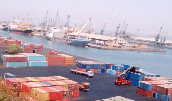
  • Located in Andhra Pradesh, Visakhapatnam Port is a land-locked harbor, connected to the sea by a channel cut through solid rock and sand.
  • Visakhapatnam Port handles iron-ore, petroleum, and general cargo.
  • Chennai Port is one of the oldest ports on the eastern coast of India.
  • Ennore is a newly developed port in Tamil Nadu. It has been constructed 25 km north of Chennai to relieve the pressure on Chennai port.
  • Tuticorin Port is also an important port located in Tamil Nadu. It handles the movement of coal, salt, food grains, edible oils, sugar, chemicals, and petroleum products.
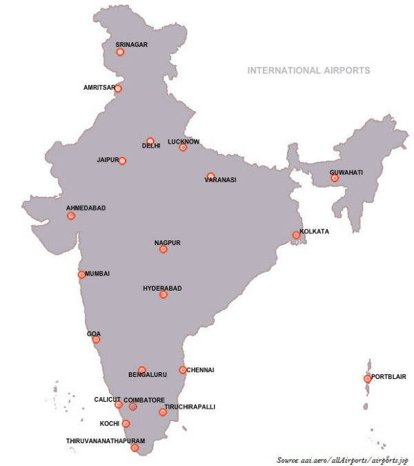
  • There were 19 international airports functioning in the country (February 2013); however, currently, it is 20.
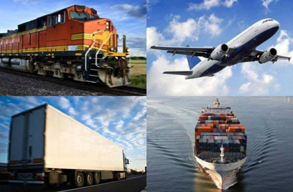
  • Airways have the advantage of taking the least time for carriage and handling high value or perishable goods over long distances; however, it is expensive and hence not suitable for the heavy and other machinery products.

Communications

Radio

  • Radio broadcasting was started in India in 1923 by the Radio Club of Bombay.
  • Government took control over radio broadcasting in 1930 and established the Indian Broadcasting System.
  • All India Radio was constituted in 1936 and it came to be known as Akashwani from 1957.
  • Over a period of time, All India Radio started broadcasting a variety of programs related to information, education, and entertainment.
  • Among all programs, news bulletins were also broadcasted at specific occasions like the session of parliament and state legislatures.

Television

  • Television first went on air in 1959.
  • Television broadcasting has emerged as an effective audio-visual medium for disseminating information as well as educating masses.
  • By 1972, many Television broadcasting centers became operational throughout the country.
  • In 1976, TV was separated from All India Radio (AIR) and got a separate identity as Doordarshan (DD).

Indian Satellites

  • With the advent of satellites, the Indian Communication System has revolutionized the mode of communication.
  • After INSAT-IA (National Television-DD1) became operational, Common National Programs (CNP) were started for the entire network. Services were also extended to the backward and rural areas of the country.
  • On the basis of configuration and purposes, satellite system in India can be grouped as −
    • Indian National Satellite System (INSAT) and
    • Indian Remote Sensing satellite system (IRS).
Indian Space Centres
  • The INSAT, which was established in 1983, is a multipurpose satellite system specialized for telecommunication, meteorological observation, and for many other data and programs.
  • The IRS satellite system became operational only after the launch of IRS-IA in March 1988 from Vaikanour, Russia.
  • However, India has also developed its own Launch Vehicle PSLV (Polar Satellite Launch Vehicle).
PSLV
  • The National Remote Sensing Centre (NRSC) at Hyderabad is responsible for acquisition, processing, supply of aerial and satellite remote sensing data and continuously exploring the practical uses of remote sensing technology.

Transport

Introduction

  • People use various methods to move goods, commodities, ideas from one place to another.
  • Land, water, and air are the major modes of transportation.
Indian Transportation
  • Land transportation includes road, rail, and pipeline.

Road

  • With a total length of about 42.3 lakh km, India has one of the largest road networks in the world.
  • About 85% of passenger and 70% of freight traffic are carried by roads.
  • Sher Shah Suri built the Shahi (Royal) road to strengthen and consolidate his empire from the Indus Valley to the Sonar Valley in Bengal.
  • This road was later renamed as the Grand Trunk (GT) Road during the British period, connecting Calcutta and Peshawar.
  • At present, GT Road extends from Amritsar to Kolkata. It is bifurcated into 2 segments − (a) National Highway (NH)-1 from Delhi to Amritsar, and (b) NH- 2 from Delhi to Kolkata.
  • Roads have been classified as National Highways (NH), State Highways (SH), Major District Roads, and Rural Roads.
  • The National Highways Authority of India (NHAI), which is an autonomous body under the Ministry of Surface Transport was operationalized in 1995.
  • The main roads connecting two or more states are constructed and maintained by the Central Government. These roads are known as the National Highways.
  • The NHAI is responsible for the development, maintenance, and operation of National Highways.
  • The National Highways constitute only 1.67 per cent of the total road length, but carry about 40 per cent of the road traffic.
  • Golden Quadrilateral is 5,846 km long 4/6 lane, high density traffic corridor that connects India’s four big metro cities : Delhi-Mumbai-Chennai-Kolkata.
India National Highway
  • With 4,076 km long road, North-South Corridor aims at connecting Srinagar in Jammu and Kashmir with Kanyakumari in Tamil Nadu.
  • With 3,640 km of road length, the East-West Corridor has been planned to connect Silchar in Assam with the port town of Porbandar in Gujarat.
  • State Highways are constructed and maintained by the state governments.
  • The State Highways join the state capitals with district headquarters and other important towns.
  • All State Highways collectively constitute about 4 per cent of the total road length in the country.
  • District roads are the roads connecting the District Headquarters and the other important nodes in the district.
  • District roads account about 60.83 per cent of the total road length of the country.
  • Further, about 80 per cent of the total road length in India come under rural roads.
  • Other roads include Border Roads and International Highways.
  • The Border Road Organization (BRO) was established in May 1960 for the acceleration of economic development and strengthening defense preparedness through rapid and coordinated improvement of strategically important roads along the northern and north-eastern boundary of the country.
  • BRO has constructed roads in high altitude mountainous terrain joining Chandigarh with Manali (Himachal Pradesh) and Leh (Ladakh), which runs at an average altitude of 4,270 meters above the mean sea level.
  • The road density is only 12.14 km in Jammu and Kashmir, whereas in Kerala it is 517.77 km.

Railways

Indian Railways
  • Railways was introduced to India in 1853, when a line was constructed from Bombay to Thane covering a distance of 34 km.
  • The total length of Indian Railways network is 64460 km. (March 2011).
  • Indian Railways system has been divided into sixteen zones (as shown in the map given below − the lines shown in different colors illustrate the regions of respective zones).
  • India has three system of railways − broad gauge (the distance between rails is 1.676 meter); meter gauge (the distance between rails is one meter); and narrow gauge (the distance between the rails is 0.762 meter or 0.610 meter).
  • Konkan Railway constructed along the western coast in 1998, is a landmark achievement of Indian Railway.
  • Konkan Railway is 760 km long rail route connecting Roha in Maharashtra to Mangalore in Karnataka.
  • Konkan Railway crosses 146 rivers, streams, nearly 2000 bridges, and 91 tunnels.
  • Asia’s largest tunnel which is about 6.5 km long, is constructed on the Konkan railway route near Ratnagiri in Maharashtra.

Waterways

Waterways of India
  • Water transport can be divided into two major categories − inland waterways and oceanic waterways.
  • India has 14,500 km of navigable waterways, contributing about 1% to the country’s transportation.
  • Currently, 5,685 km of major rivers is navigable by mechanized flat bottom vessels.
  • Inland Waterways Authority was set up in 1986 for the development, maintenance, and regulation of national waterways in the country.
  • Major National Waterways (NW) of India are NW 1 (Allahabad-Haldia covers 1,620 km); NW 2 (Sadiya-Dhubri covers 891 km); and NW 3 (KottapuramKollam covers 205 km).
  • Besides, NW 4 covers specified stretches of rivers Godavari and Krishna along with Kakinada Puducherry; the total distance is 1078 km.
  • NW 5 covers specified stretches of river Brahmani along with Matai river, delta channels of Mahanadi and Brahmani rivers and East Coast canals; the total distance is 588 km.
  • With 12 major and 185 minor ports, India has a vast coastline of approximate 7,517 km, including islands.
  • Roughly 95% of India’s foreign trade by volume and 70% by value moves through ocean routes.

Airways

  • Air transport in India marked its beginning in 1911 with the commencement of airmail over a little distance of 10 km between Allahabad and Naini.
International Airports
  • The Airport Authority of India is accountable for providing safe, efficient air traffic, and aeronautical communication services in the Indian Air Space.
  • Pawan Hans is the helicopter service operating in hilly areas and is widely used by tourists in north-eastern regions.

Pipelin

Indian Pipelines
  • Asia’s first cross country pipeline covering a distance of 1,157 km was constructed by Oil India Limited (OIL) from Naharkatiya oilfield in Assam to Barauni refinery in Bihar, which further extended up to Kanpur in 1966.
  • Mumbai High-Koyali and Hazira-Vijaipur-Jagdishpur (HVJ) are the most important pipelines in India.
  • 1256 km long pipeline between Salaya (Gujarat) and Mathura (U.P.) has been constructed recently.

Industry

Introduction

  • On the basis of size, capital investment, and labor force employed, industries are classified as large, medium, small scale, and cottage industries.
Indian Industry
  • On the basis of ownership, industries come under public sector, private sector, joint, and cooperative sector.
  • Industries of strategic and national importance are usually in the public sector.
  • Industries are also classified on the basis of the use of their products such as basic goods industries, capital goods industries, intermediate goods industries, and consumer goods industries.
  • On the basis of raw materials used by the industries − industries are categorized as agriculture-based industries, forest-based industries, mineral-based industries, and industrially processed raw material-based industries.
  • Location of industries is influenced by several factors like access to raw materials, power, market, capital, transport, and labor, etc.
  • Establishment of iron and steel industry in Bhilai (Chhattisgarh) and Rourkela (Odisha) were based on decision to develop backward tribal areas of the country.

Iron and Steel Industry

  • The major raw materials for the iron and steel industries are iron ore, coking coal, limestone, dolomite, manganese, and fire clay.
  • Major iron and steel industries in India are −
    • The Tata Iron and Steel plant (TISCO);
    • The Indian Iron and Steel Company (IISCO);
    • Visvesvaraiya Iron and Steel Works Ltd. (VISL);
    • Rourkela Steel Plant;
    • Bhilai Steel Plant;
    • Durgapur Steel Plant; and
    • Bokaro Steel Plant.
  • Some other major iron and steel industries are −
    • Vizag Steel Plant, in Vishakhapatnam in Andhra Pradesh is the first port based plant which started operating in 1992.
    • The Vijaynagar Steel Plant at Hosapete in Karnataka was developed by using indigenous technology.
    • The Salem Steel Plant in Tamil Nadu was commissioned in 1982.
  • The Rourkela Steel plant was set up in the year 1959 in the Sundargarh district of Odisha in collaboration with Germany.
  • The Bhilai Steel Plant was established in 1959 with Russian collaboration in Durg District of Chhattisgarh.
  • Durgapur Steel Plant was established in 1962 in West Bengal, in collaboration with the government of the United Kingdom
  • Bokaro steel plant was set up in 1964 at Bokaro with Russian collaboration.

Cotton Industry

  • India was famous worldwide for the production of muslin, a very fine variety of cotton cloth, calicos, chintz, and other different varieties of fine cotton cloth.
  • In 1854, the first modern cotton mill was established in Mumbai.
  • At present, the major centers of the cotton textile industry are Ahmedabad, Bhiwandi, Solapur, Kolhapur, Nagpur, Indore, and Ujjain.
  • Tamil Nadu has the largest number of mills; however, most of them produce yarn rather than cloth.
  • Davangere, Hubballi, Ballari, Mysuru, and Bengaluru are important cotton growing regions in Karnataka.

Sugar Industry

  • With more than one-third of the total production, Maharashtra has emerged as a leading sugar producer in the country.
  • Uttar Pradesh is the second largest producer of sugar.

Petrochemical Industry

  • Many items are derived from crude petroleum, which provide raw materials for many new industries; hence, these are collectively known as petrochemical industries.
  • Petrochemical industries are categorized as polymers, synthetic fibers, elastomers, and surfactant intermediate industries.
  • Mumbai is the hub of petrochemical industries.
  • Three organizations, which are working in the petrochemical sector under the administrative control of the Department of Chemicals and Petrochemicals are −
    • The Indian Petrochemical Corporation Limited (IPCL);
    • The Petrofils Cooperative Limited (PCL);
    • The Central Institute of Plastic Engineering and Technology (CIPET).
    • The National Organic Chemicals Industries Limited (NOCIL), established as private sector in 1961.

Information Technology

  • The Information Technology (IT) revolution opened up new possibilities of economic and social transformation.
  • The IT software and services industry account for almost 2% of India’s GDP.

Industrial Policy

  • The new Industrial Policy was implemented in 1991.
  • The new industrial policy has three main dimensions − liberalization, privatization, and globalization.
  • Within this new industrial policy, measures initiated are − abolition of industrial licensing; free entry to foreign technology; foreign investment policy; access to capital market; open trade; abolition of phased manufacturing program; and liberalized industrial location program.
  • Globalization means integrating the economy of the country with the world economy.

Industrial Regions

  • India has eight major industrial regions namely (as shown on the map given below) −
    • Mumbai-Pune Region,
    • Hugli Region,
    • Bengaluru-Tamil Nadu Region,
    • Gujarat Region,
    • Chhotanagpur Region,
    • Vishakhapatnam-Guntur Region,
    • Gurgaon-Delhi-Meerut Region, and
    • Kollam-Thiruvananthapuram Region.
Major Industrial Regions